An Analysis of the Seismicity of the Puget Sound Region
A Report Prepared for the Washington Public Power Supply System
Kenneth A. Piper, October, 1978
INTRODUCTION
This report analyzes the seismicity of the Puget sound region, its probable causes, and possible reasons for its concentration in this area. A fundamental question is whether the seismicity of the Puget Sound region is due to plate interaction with a subducting part of the Juan de Fuca plate, or whether it is due to crustal inhomogeneities under the influence of a stress field in the upper plate. If the former, what is the nature of that interaction? And, what is the cause of the crustal stress field? Geophysical evidence is analyzed to aid in an understanding of the regional and local tectonics and is checked for consistency with geologic information.
GEOLOGIC SETTING
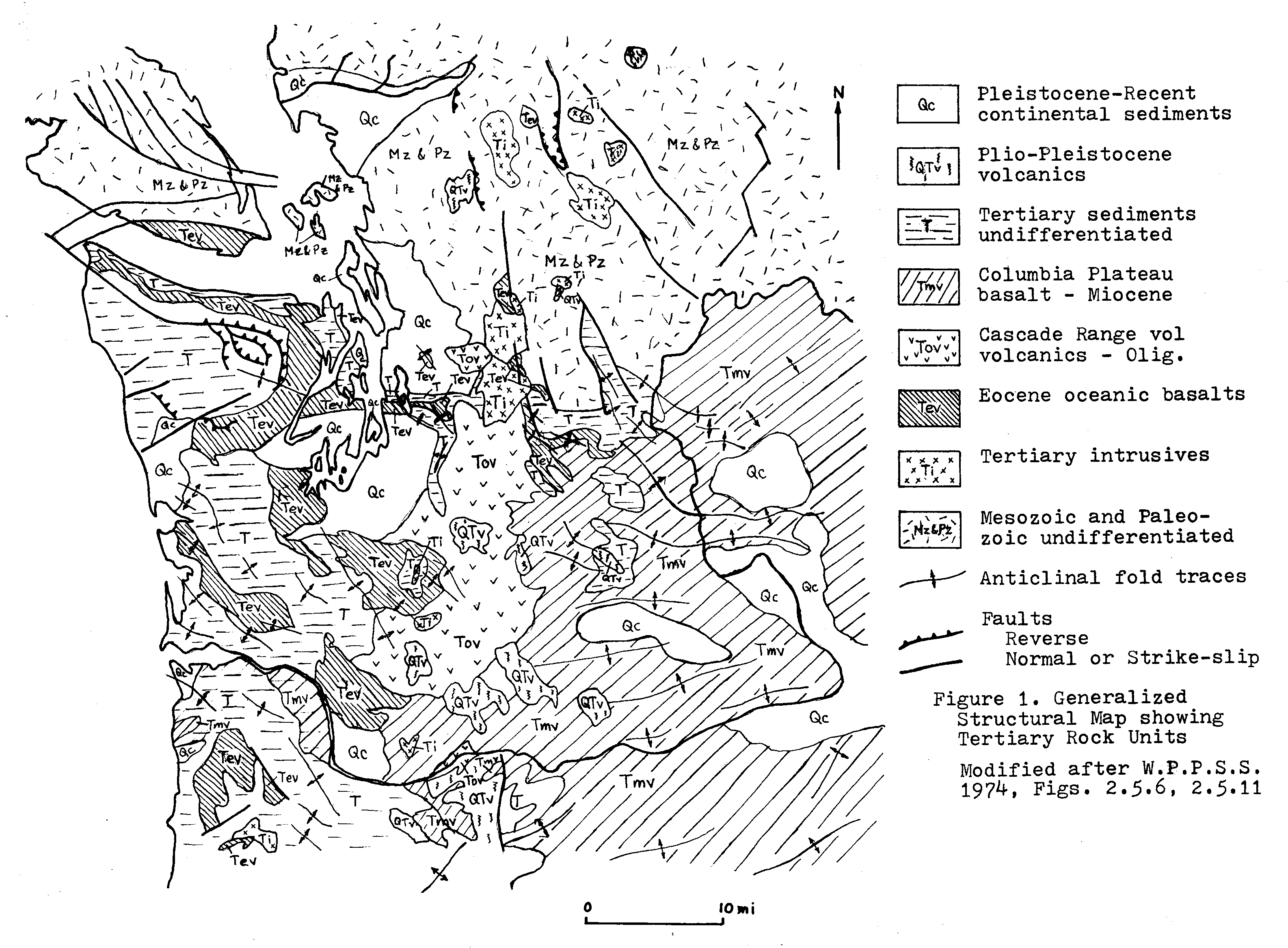
A generalized geologic map of the region surrounding the Puget trough is shown in figure 1. To the east of the Puget trough is the Cascade Mountain Range. To the south, a possible continuation of the trough becomes the Willamette Valley of Oregon. To the west are the coastal ranges, including the Olympic Mountains, the Willapa Hills area, and the Oregon Coastal Mountains.
The Cascade Range is a broad north-south-trending structural arch of mostly Tertiary volcanics capped by a series of Quaternary volcanoes. Elevations averaging 4,000-5,000 feet in Oregon and southern Washington increase northward to about 7,000 feet in northern Washington. The Quaternary volcanoes mostly exceed 10,000 feet in elevation. To the south of a line which trends approximately northwest from Yakima to south of the San Juan Islands, only Cenozoic rocks are present. To the north, the rock types include pre-Tertiary crystalline and sedimentary rocks, and more extensive exposures of Tertiary granitic batholiths. Although most of the Quaternary volcanoes are on the eastern flanks of the Cascade Mountains, in Washington the volcanoes showing the most recent activity are on the west side (Mts. Baker, Rainier, St. Helens). Those on the east side (Mt. Adams, Glacier Peak) seem to be inactive at the present. This may be indicative of a westward shift in the locus of volcanic activity.
The Olympic Mountains are a topographically high area (in places exceeding 7,000 feet) which forms a peninsula west of the Puget lowlands that is separated from Vancouver Island by the Straits of Juan de Fuca. Its general structure is an eastward plunging antiform with steeply-outward-dipping flanks to the north, east and south. Early Tertiary oceanic basalts and associated sedimentary rocks on the northern, eastern, and southern flanks of the range structurally overlie marine sedimentary rocks of younger age in the central Olympics. The Olympics are most likely a folded imbrication of oceanic crustal rocks and continental margin sediments, uplifted to their present structurally high position in late Cenozoic time (MacLeod, et al, 1977).
The Willapa Hills area just south of the Olympics is, by contrast, a region of much lower relief; elevations rarely exceed 2,000 feet. It may be considered as a low northern extension of the Oregon Coast Range, although the structural trend is slightly different. The Oregon Coast Range is a north-south-trending anticlinorium with smaller northeast-trending folds. The Willapa Hills area has mostly northwest-trending folds and reverse faults, and northeast-trending normal faults (Washington Public Power Supply System, 1974). The Oregon Coast Ranges and Willapa Hills are probably also an imbrication of oceanic crustal rocks.
The Puget trough is a north-south-trending structural basin that has been topographically modified by Quaternary glaciation and filled with great thicknesses of Quaternary sediments. The surface topography is expressed as a series of generally north-trending islands and peninsulas separated by steep-sided channels. Trough to crest relief is on the order of 600 to 1,000 feet. The steep-sided channels may be due entirely to glacial action or may be in part of structural origin. The basin is apparently a youthful feature, with as much as 3,600 feet of unconsolidated, mostly Quaternary sediments (Hall & Othberg, 1974). Mesozoic and Tertiary sedimentary, metasedimentary, and volcanic rocks crop out to the north in the San Juan Islands and near Bellingham (Huntting, et al, 1961), and underlie the Quaternary sediments in the Bellingham area (Livingston, 1958).
In the southern part of the Puget trough, no pre-Tertiary rocks are found. Tertiary volcanics and sedimentary rocks occur on an east-west trend through Seattle and Bremerton (fig. 1). These rocks dip uniformly northward from about 40°N to slightly overturned (80E°S). North of these outcrops, the thickness of unconsolidated Quaternary sediments increases to at least 3,600 feet in a few miles distance (Hall & Othberg, 1974).
Tide gauge records indicate that some basin areas are subsiding. The Seattle area, for example, is subsiding relative to the San Juan Islands (Mathews, et al, 1970). The elevation changes may be the surface expression of continuing tectonic activity which is evidenced at depth by the local seismicity. The thick accumulation of unconsolidated sediments absorbs most of the abrupt displacement of faulting and results in gentle flexure at the surface rather than surface rupture.
REGIONAL GRAVITY AND DENSITY STRUCTURE
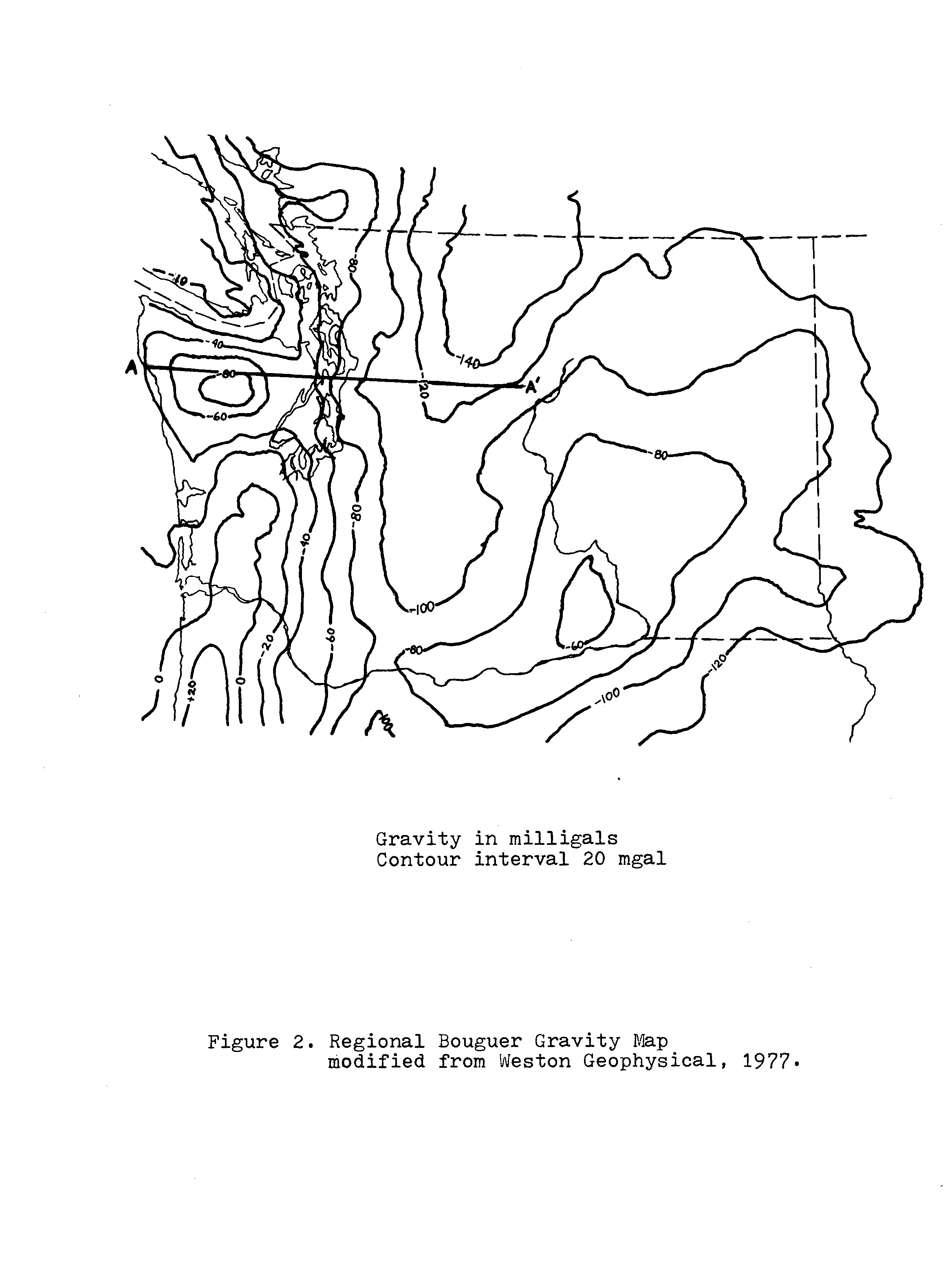
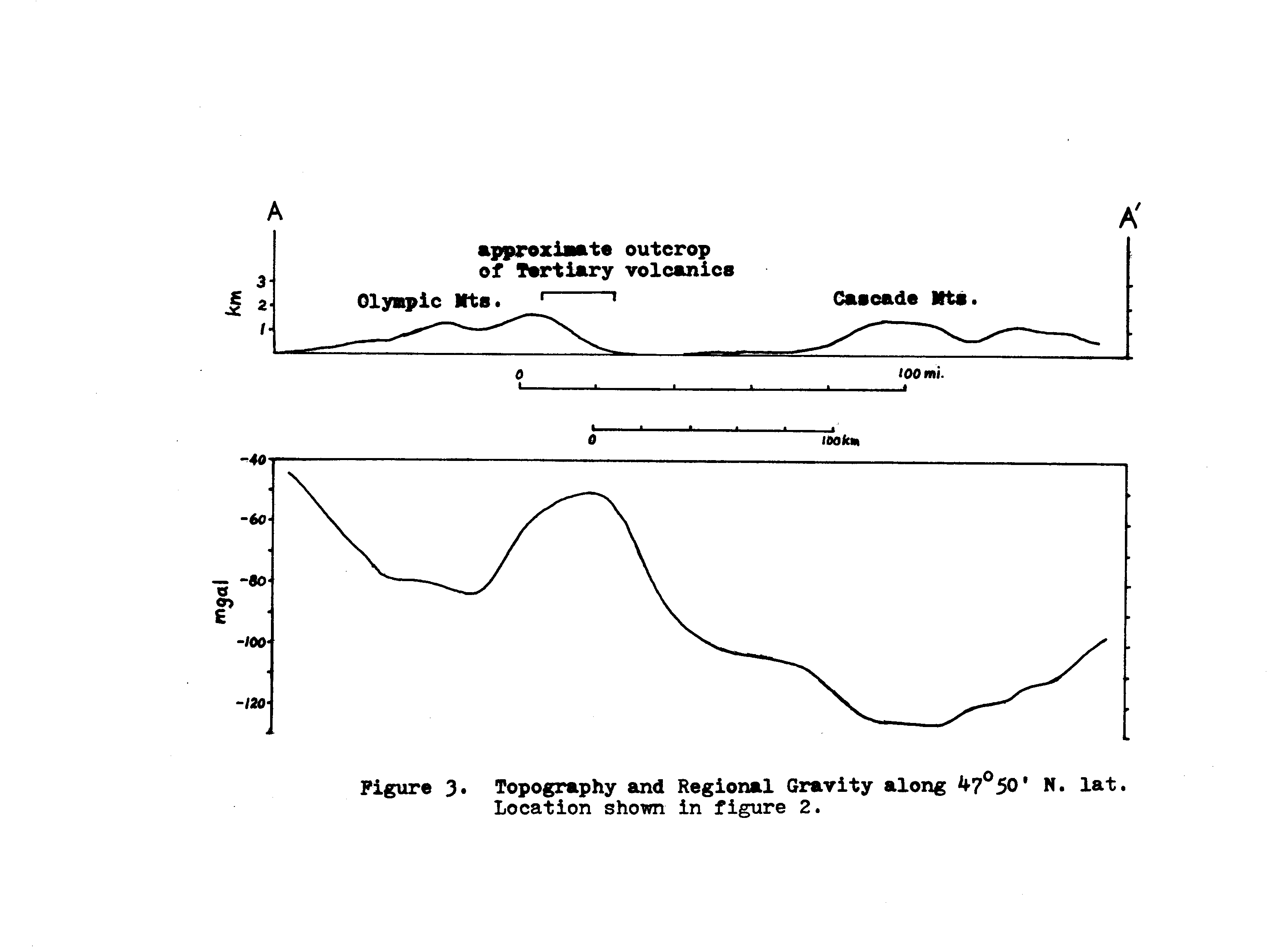
A map of the regional Bouguer gravity (Weston Geophysical, 1977) is shown in figure 2. Total Bouguer values were averaged over 40 square mile areas to obtain the regional values for this map. As is suggested by an east-west profile across the Cascades and Olympics, the regional gravity field is compatible with a state of isostasy for northern Washington (fig. 3). The large negative anomalies associated with the high topographic areas in the Olympic and Cascade Mountains are a result of a low density “root” which supports the mountains isostatically at greater elevations than for areas of thinner crust. The relatively high regional gravity centered at the western margin of the Puget trough may be due in part to thinner crust, but is probably mostly due to large quantities of high density rocks, as discussed below. The coastal ranges south of the Olympics have a positive Bouguer anomaly (fig. 2). This may be due to a change in crustal thickness from north to south or may also be due to density differences.
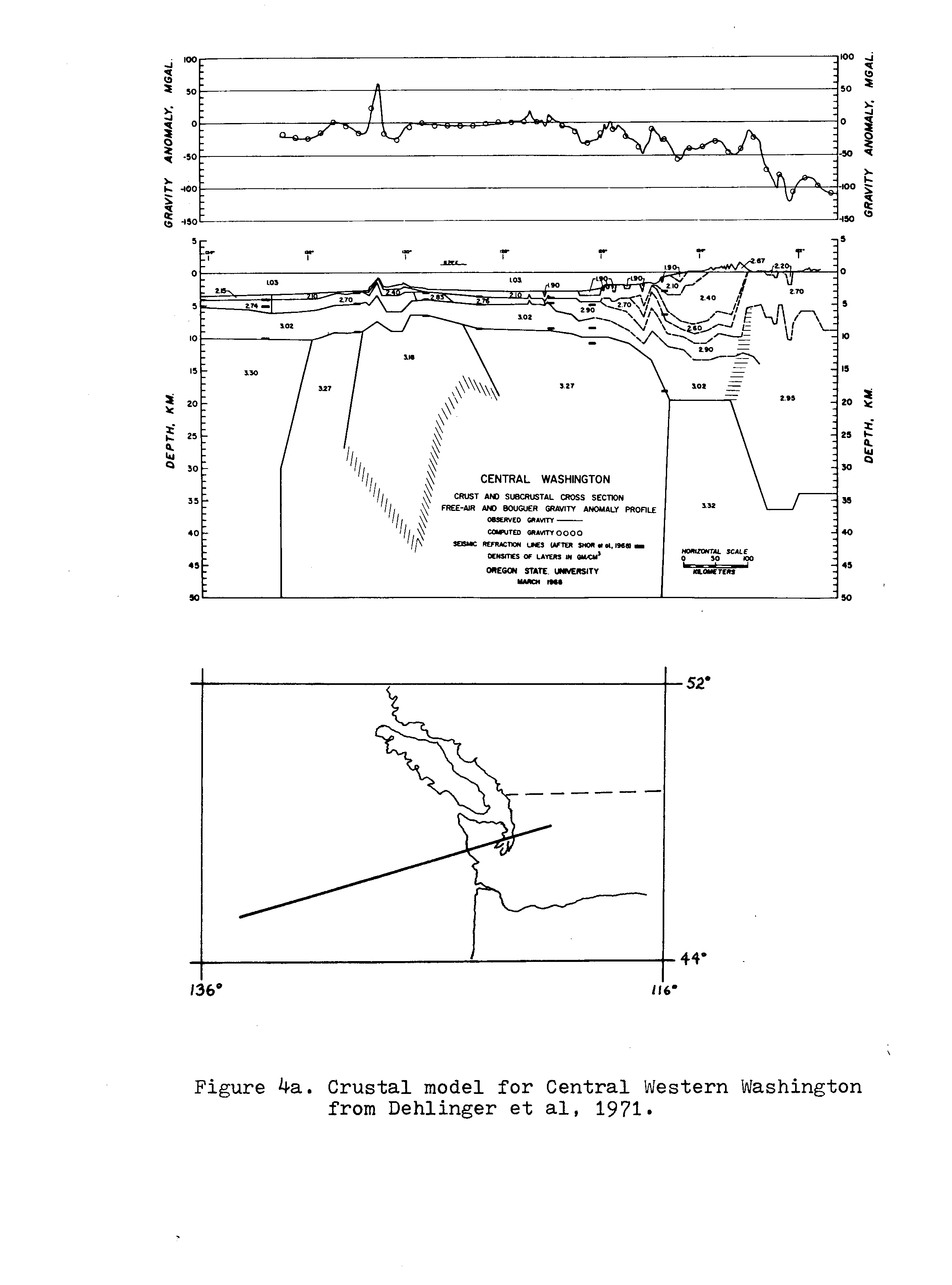
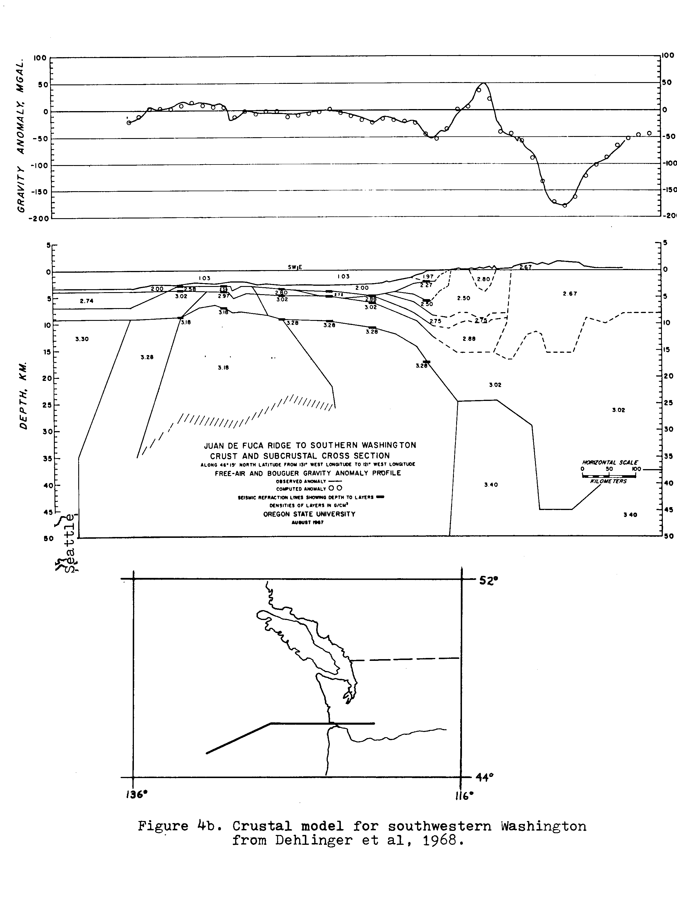
The models by Dehlinger, et al (1968, 1971) for the Olympics and northern Oregon Coast Range primarily use density differences to account for varying anomalies. For the southern Olympics, a 20 km thick crust with an average density of 2.7 gm/cc is shown (fig. 4a) whereas for the northern Oregon Coast Mountains (Willapa Hills area, fig. 4b) a 25 km crust with an average density of 2.84 is shown. These models were based primarily on gravity and offshore refraction data. Berg, et al (1966), using onshore seismic refraction data of a large man-made explosion, determined a crustal thickness of only about 16 km for the Oregon Coast Ranges into southern Washington. MacLeod, et al (1977), noting the lack of refraction data for the central Olympics, postulate a thickened crust for the Olympics with a major fraction being relatively low-density sedimentary rocks as found in the central part of the mountains. Most likely, a combination of thinner crust and a greater proportion of relatively high density basaltic rocks in the Oregon Coast Range account for the positive gravity anomaly as compared to the Olympic Mountains.
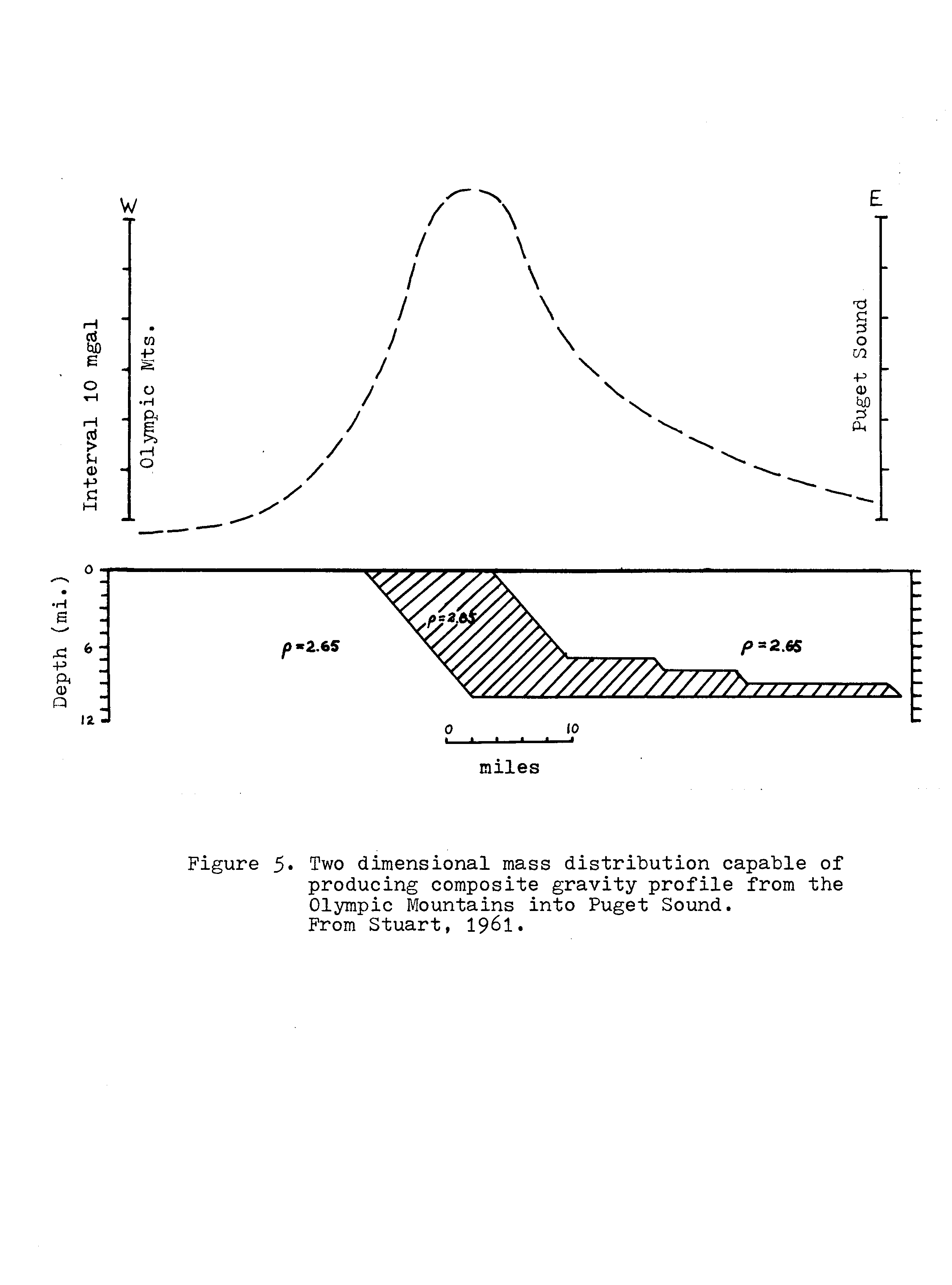
A band of relatively high gravity (low negative values) extends north from the Willapa Hills area along the eastern Olympics and western Puget lowlands (figs. 2,3). Stuart (1961) notes that the gravity high correlates well with outcrops of Eocene basaltic volcanics. The steep gravity gradients require a great thickness of lower density sediments (on the order of tens of thousands of feet) to the east, juxtaposed against a similar thickness of volcanics. Figure 5, from Stuart (1961) shows one of many possible mass distributions which can account for this anomaly.
LOCAL GRAVITY
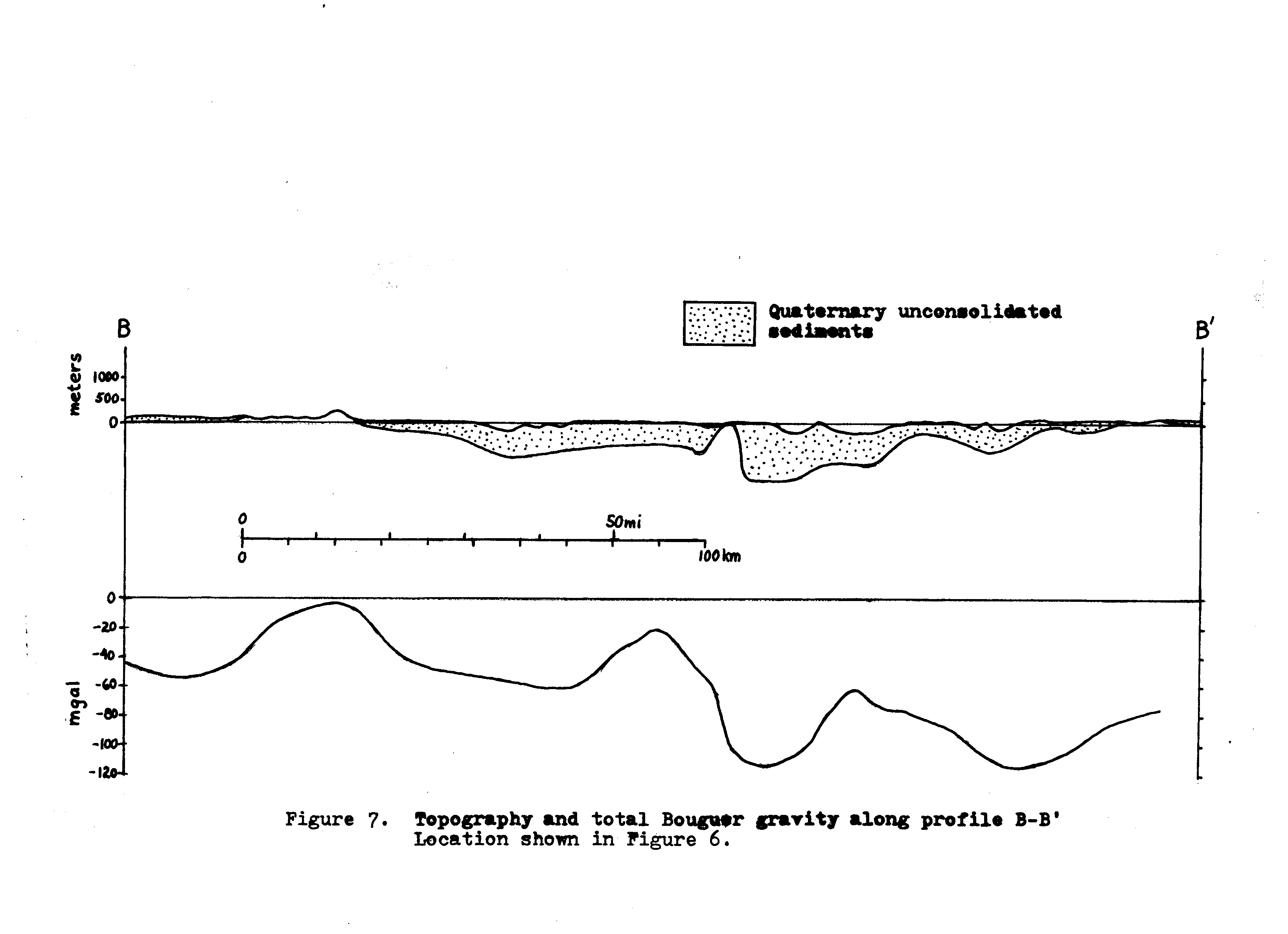
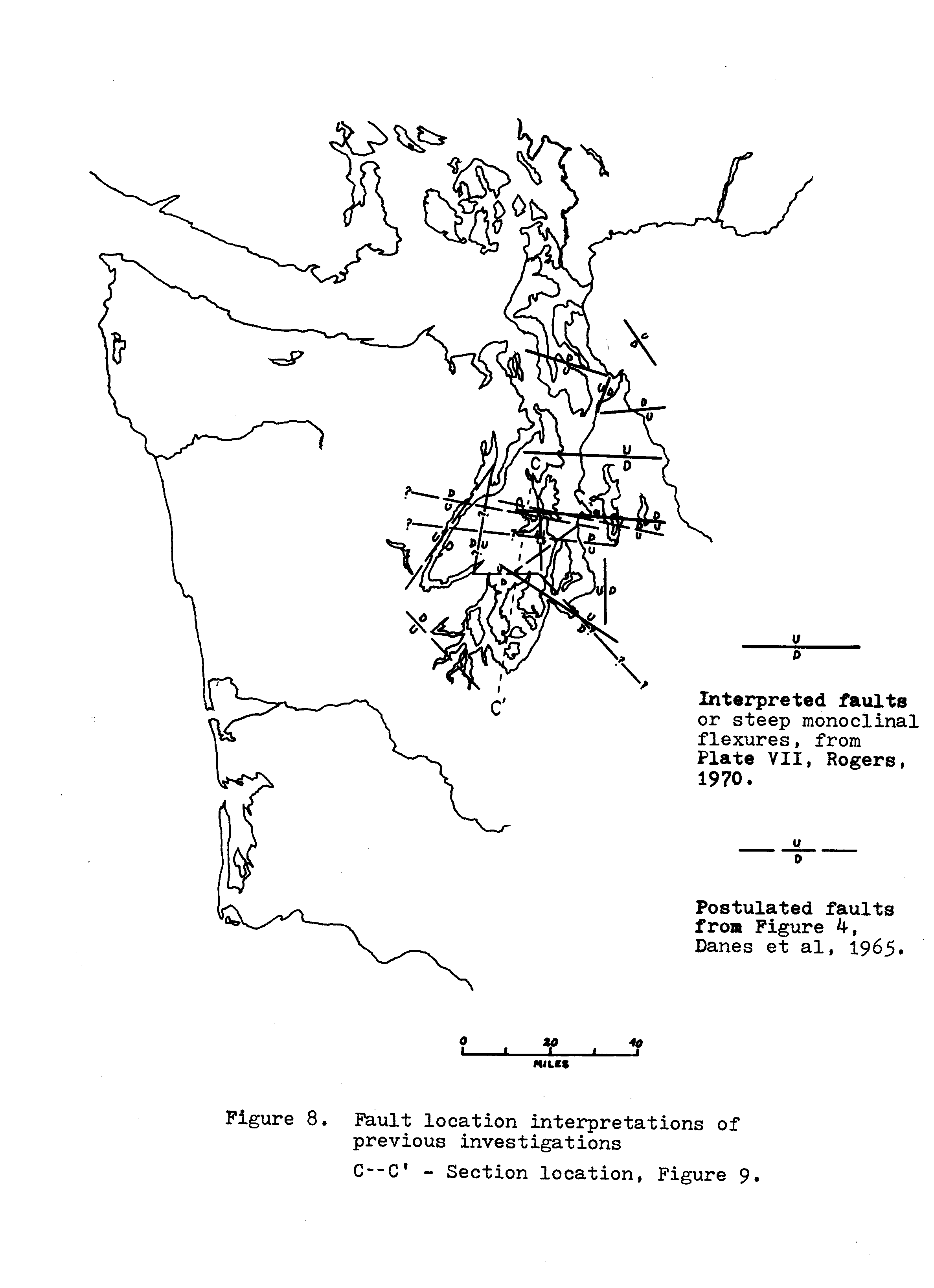
A total Bouguer gravity map for the Puget trough is shown in figure 6. As shown in the regional cross-section (fig. 3) the Puget trough has, on the average, small-negative Bouguer values bounded by larger negative values associated with the Olympic and Cascade Mountain Ranges. Within the trough, the total Bouguer anomaly consists of a series of large- and small-negative valued anomalies with dimensions of about 20 to 50 km and aligned in a north-northeast direction, approximately parallel to the topographic trough. Gradients between the high and low values range from moderate to very steep; some among the steepest in North America (fig. 7). The gravity pattern has been interpreted previously (Danes, et al, 1965; Rogers, 1970) as indicative of fault bounded blocks.
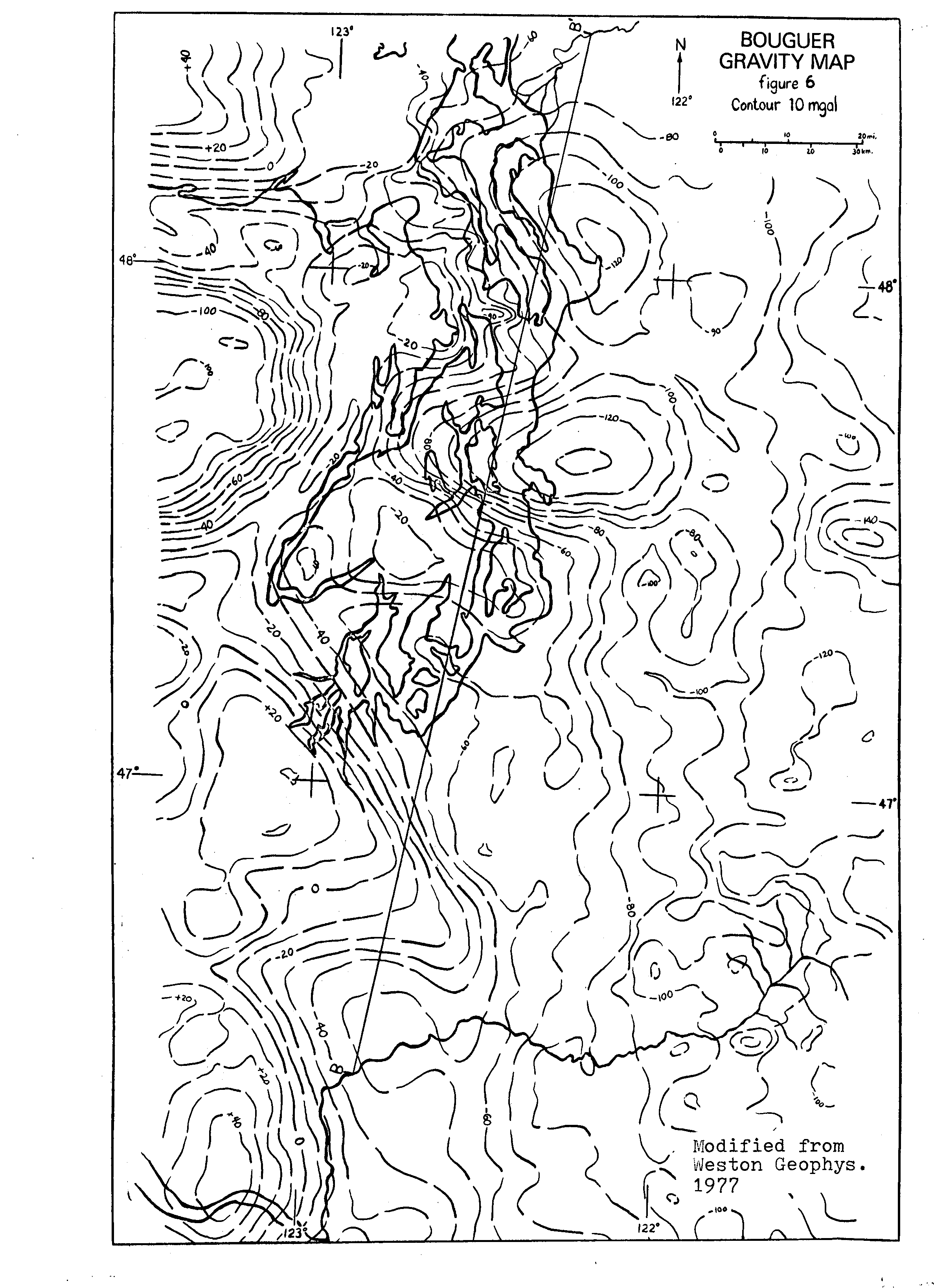
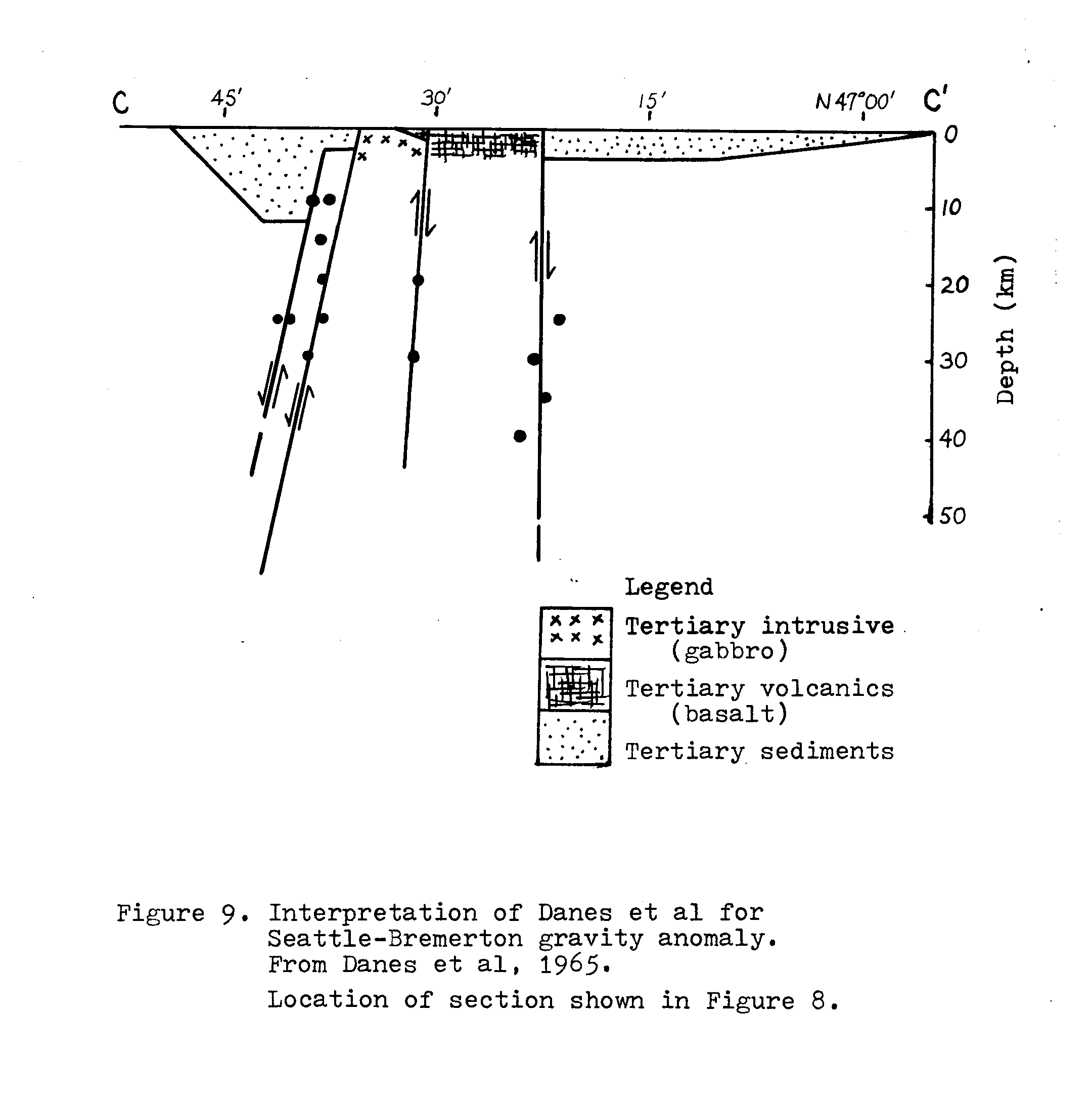
Danes, et al consider the volcanic and sedimentary rock outcrops on the Seattle-Bremerton trend (fig. 1) to be a horst bounded by several active east-went trending faults with tens of thousands of feet offset. Two large-displacement faults along the north side of this feature are considered responsible for the steep gravity gradient (figs. 8,9). They also claim evidence for an active fault approximately parallel to Hood Canal, separating the Olympics from the Puget lowlands.
The interpretation of Rogers (1970) is based primarily on gravity data, but also considers magnetic data. He shows a fault (or steep monoclinal flexure) along each of the more linear zones of steep gradient (fig. 8). Basin topography (fig. 7) supports several of Rogers’ fault interpretations, but suggests some are mislocated. For his Seattle-Bremerton fault, Rogers includes as additional evidence the uniformly north-dipping outcrops along the south side of this trend.
SPATIAL DISTRIBUTION OF SEISMICITY
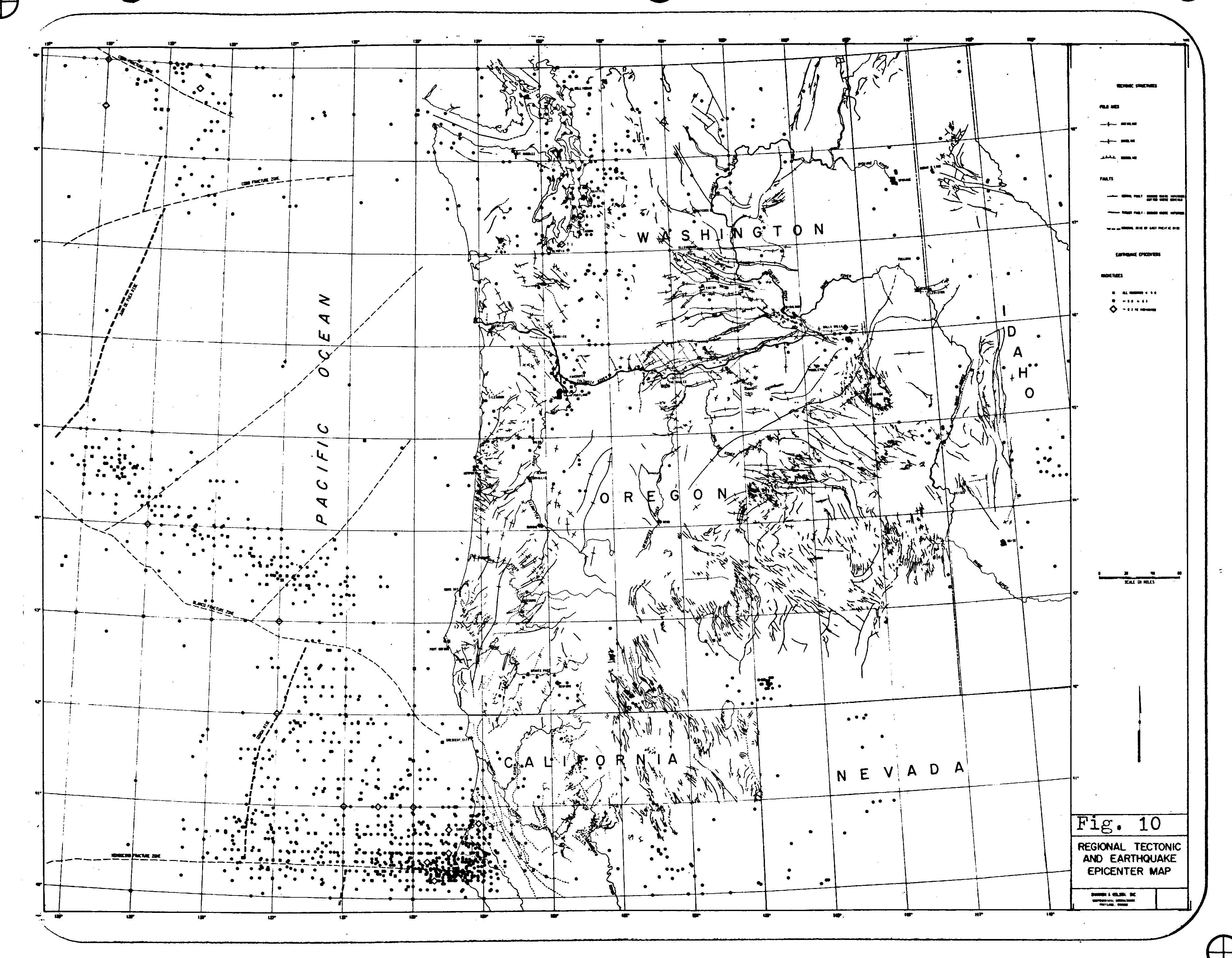
In the western Washington region, the majority of earthquake activity is concentrated along a broad north-south trend which corresponds with the Cascade Mountains and the Puget- Willamette trough. Except for a peak in the vicinity of Portland, seismicity south of Puget Sound is at a slightly lower level than to the north, and is associated more closely with the Cascade Mountains (fig. 10). Subcrustal earthquakes have occurred in the Puget Sound area and also in the Portland and Vancouver Island areas, although the deepest events are no more than about 100 km depth. Assuming these subcrustal earthquakes are associated with a subducting slab, the small maximum depth is not surprising. According to Riddihough and Hyndman (1976), because of the relative youth of the subducted part of the plate (it is relatively warm and thin) earthquakes would not be expected below about 75 km for any part of the Juan de Fuca plate.
Crossen’s (1972) data for the period June 1970 to July 1971 was used in an analysis of the seismic distribution within and near the Puget trough (fig. 11). The large number of crustal events does show definite patterns; however the addition of more recent data would improve reliability and might indicate patterns for subcrustal seismicity.
The shallowest events (less than 10 km depth) occurred most frequently in the east (Cascade Mountains) and in the south (mostly south of the Puget Sound waterways; see fig. 11). Most of the deeper earthquakes tended to occur in the western and southwestern Puget trough. Very few events less than 10 km deep occur west of about 123° W. Only one event west of 123° W is included in Crossen’s 1972 data set, although several more have been located in a more recent data collection (Crossen & Millard, 1975).
Twelve clusters of closely spaced earthquakes were noted (A-L, fig. 11) and appear to indicate swarm activity in discrete zones. In one swarm (L) twelve events occurred during the last eleven days of the data collection period and define a northwest-trending zone about 5 km long under the eastern shores of Lake Washington, just east of Seattle. The events ranged from 27.8 to 29.2 km depth, according to Crossen’s (1972) calculations.
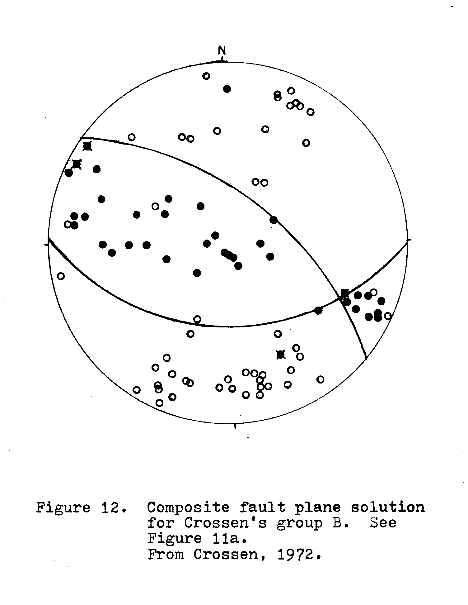
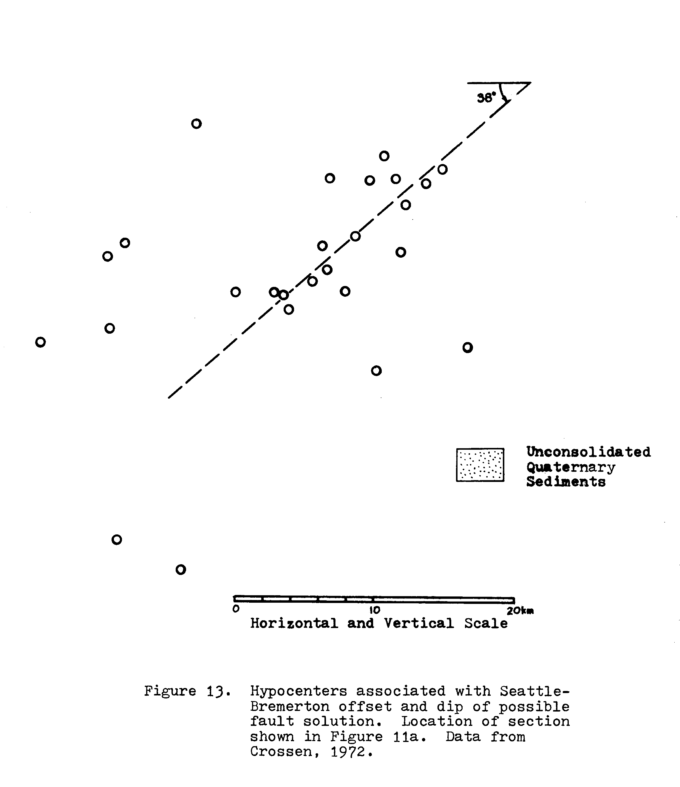
Twenty-six earthquakes (fig. 11a) define a fault zone which corresponds well with the surface location of Danes’ (1965) and Rogers’ (1970) proposed east-west faults west of Seattle. These events comprise the majority of Crossen’s (1972) group B, for which a composite fault plane solution is shown (fig. 12). A cross-section showing the offset of quaternary sediments and focal depths is shown in figure 13. The south-dipping nodal plane from Crossen’s composite solution is superimposed on the cross-section. Crossen’s fault plane solution indicates predominantly reverse faulting with a small strike-slip component. If the south-dipping plane is correct, this would be left-lateral motion.
The deeper earthquakes (greater than 50 km depth) show no definite pattern. This may be due in part to the low number of events in the data sample. Also, according to Crossen (1972) events greater than about 50 km depth are not accurately located because of the uncertainty of the velocity structure used in the computations.
FAULT PLANE SOLUTIONS
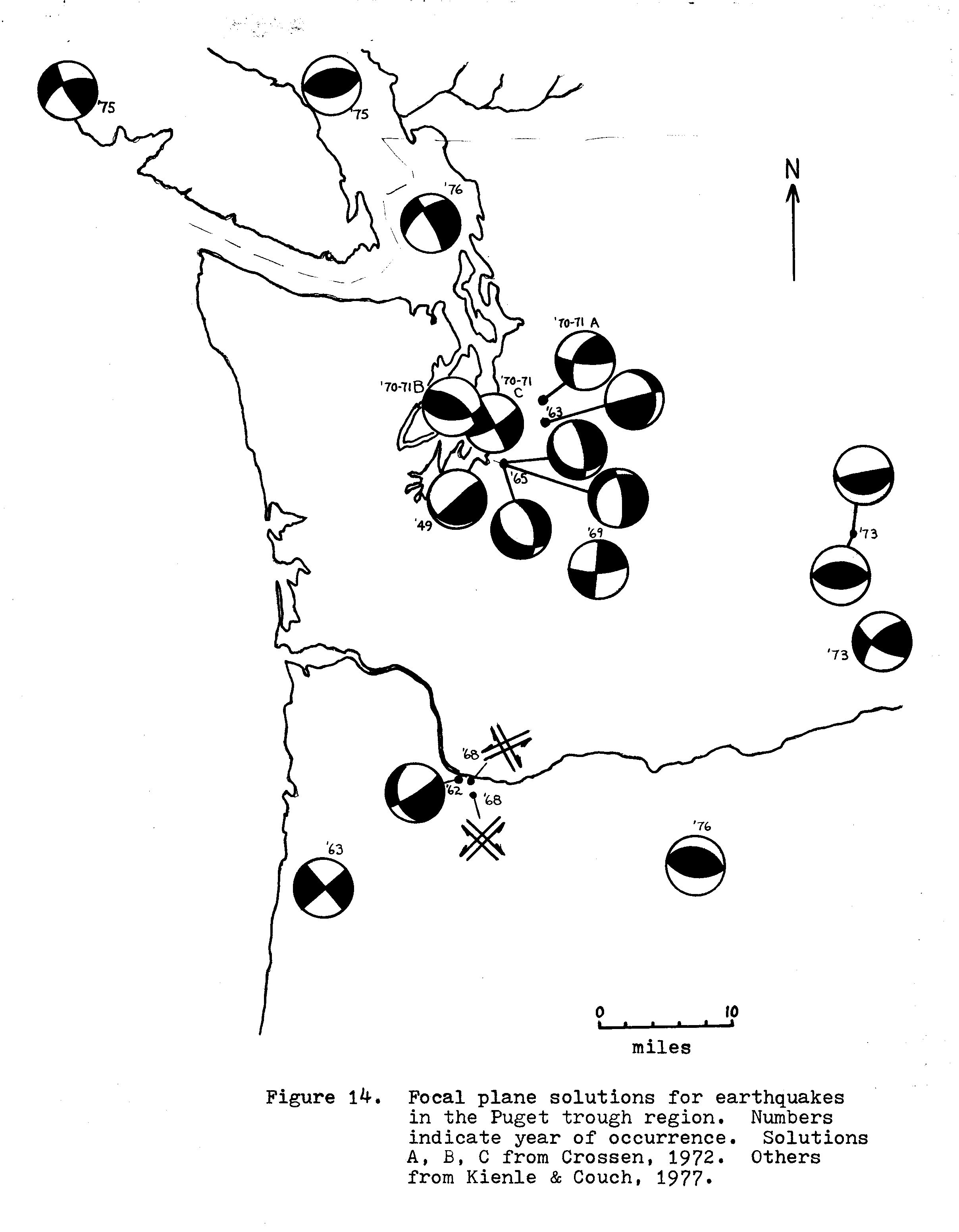
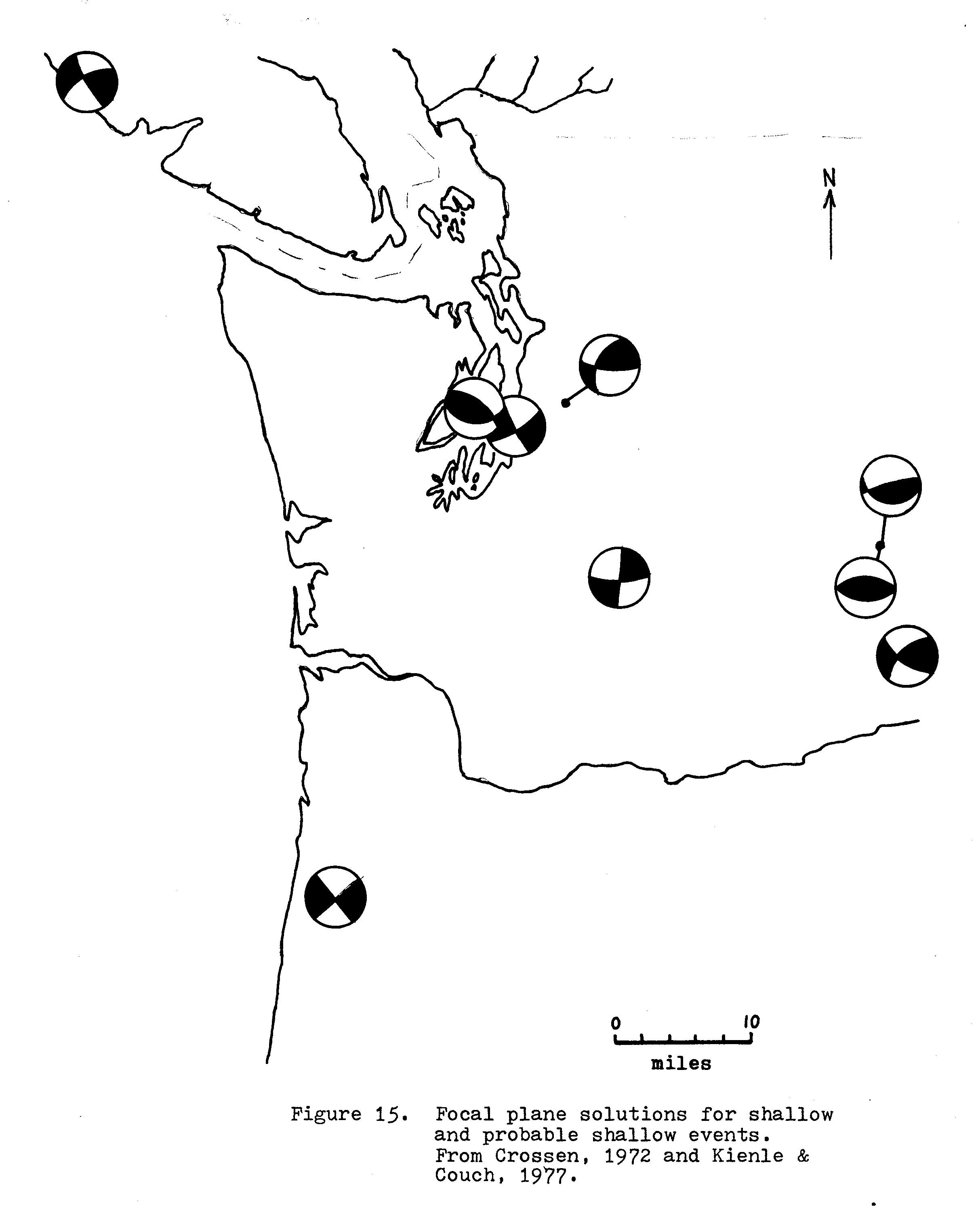
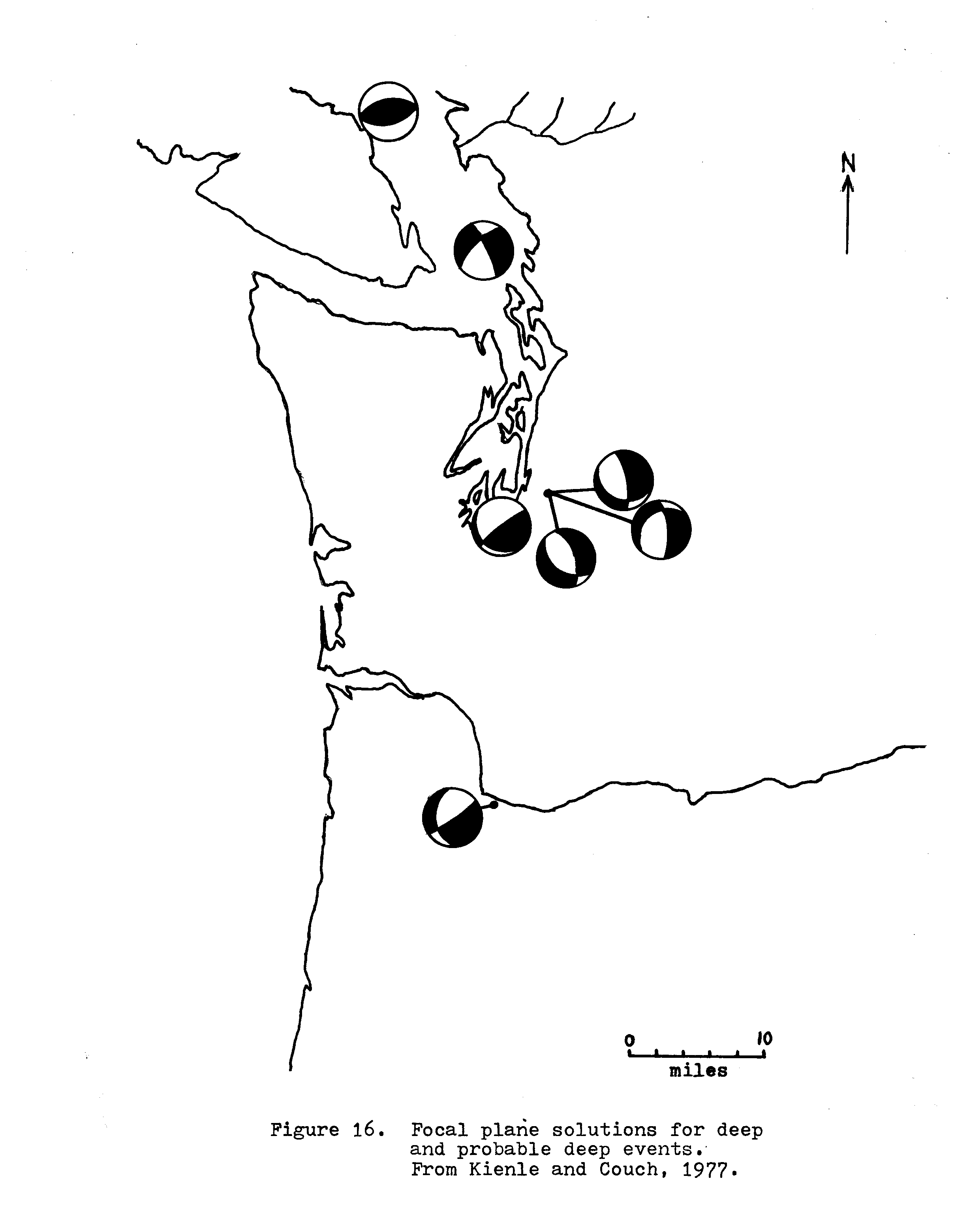
A recent compilation of fault plane solutions for the western Washington region (Kienle and Couch, 1977; Crossen, 1972) is shown in figure 14. Solutions A, B, and C are the composite solutions of Crossen (1972). The others are single events. Solutions connected to one point are different proposed solutions for the same event. In order to get a better understanding of the stress geometry, the solutions were separated into two groups — events less than 40 km depth and events greater than 50 km depth (figs. 15,16). Earthquakes deeper than about 40-50 km are almost certainly beneath the crustal portion of the North American plate and may be within or in the boundary zone of the subducted part of the Juan de Fuca plate. The lack of solutions in the 40-50 km range also makes this a convenient cutoff. Crossen’s group A is included among the shallow solutions despite one deep event (63 km). This event accounted for only three of eighty-six station readings used in this solution and is considered negligible.
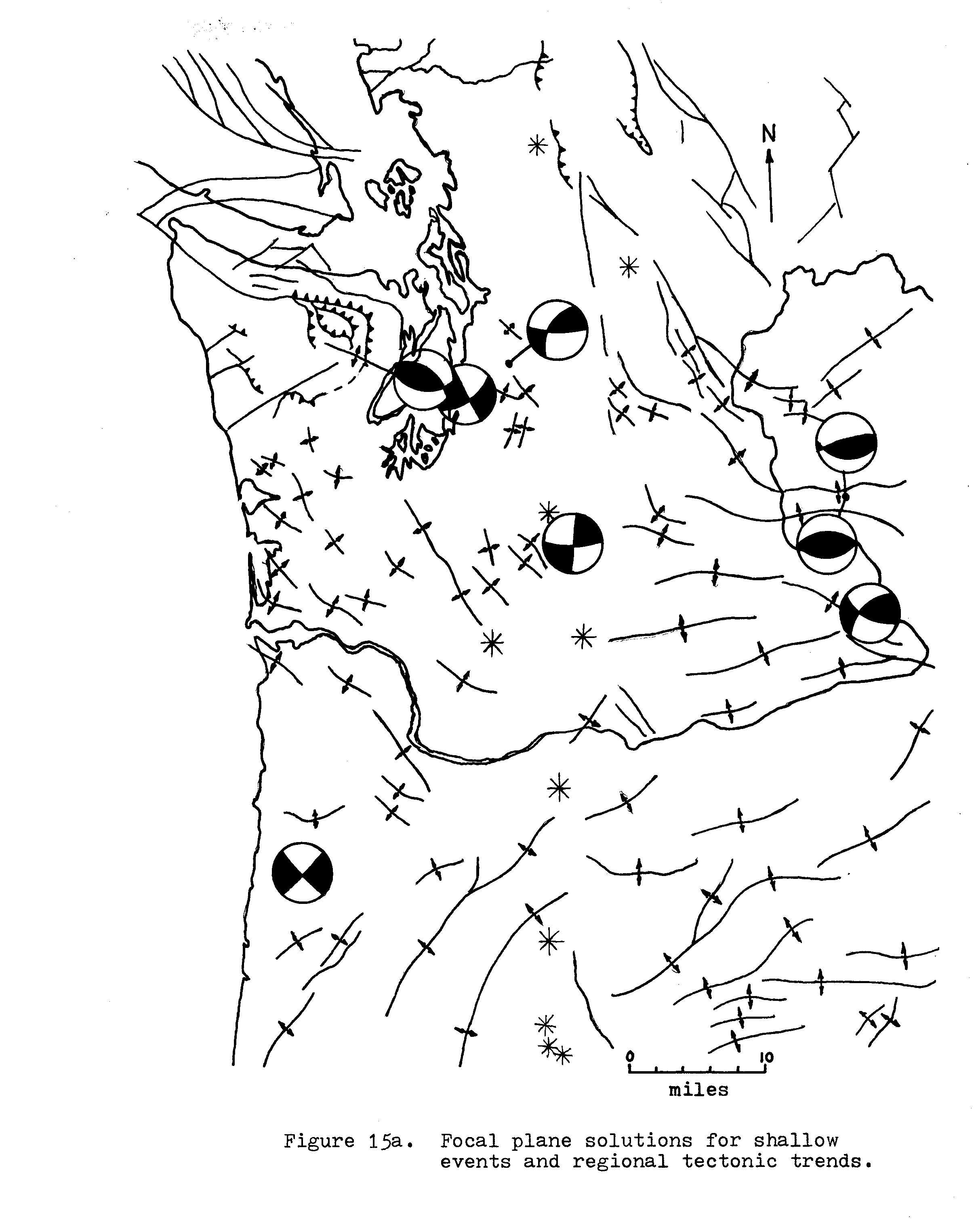
The solutions for shallow events (fig. 15) have the apparent maximum compressive stress direction (σ1; 45° from nodal planes) oriented north-northwest to north-northeast. If the composite solutions of Crossen (1972) are valid representations of the local stress field, they show a progressive change in the orientation of apparent principal stress axes from west to east across the Puget trough. West to east the σ1 direction varies from NNE-horizontal to NNW-horizontal, and the σ3 direction varies from nearly vertical to nearly horizontal. This may be explained as slight local variations in a regional north-south compressive stress field as advocated by Kienle and Couch (1977) and Davis (1977).
Six of the eight solutions indicate primarily strike-slip motion, and all of the shallow solutions are compatible with a uniform north-south compressive stress field on pre-existing planes of weakness. The present pattern does not appear to be consistent with present-day east-west normal faulting in the western Puget trough as, for example, on the postulated fault along Hood Canal (Danes, et al, 1965; fig. 8).
To see how the apparent present-day stresses compare with past strain indicators, the shallow fault plane solutions are superimposed on a regional tectonic map. As shown in figure 15a, the fault plane solutions are compatible with the dominant patterns of folding and faulting.
The fault plane solutions for deeper events (greater than 50 km depth) are shown in figure 16. The apparent σl directions are oriented north-northeast to north-northwest with variable plunge. If the apparent stresses are due to interaction between a subducting and overriding plate, then the subduction clearly has a large lateral component.
Some or all of the earthquakes may be occurring within the subducting slab. If so, the stress field should be due to some combination of surface tractions caused by interaction with the overriding plate and internal stresses caused by bending, gravitational forces and phase-change-induced density variations.
Surface tractions would be expected to induce a stress field with σ1 aligned in the direction of plate convergence and σ3 nearly vertical (fig. 17a). Bending stresses can result from several situations, two of which may occur in the western Washington region. Abrupt-bending about a horizontal axis has been suggested (Davis, 1977) as occurring beneath Puget Sound. If it is assumed that the 1965 Tacoma earthquake (fig. 16, event D; 57-60 km depth) is in the lower plate, and if Dickinson’s (1970, 1975, 1977) depth relations for arc-type magma generation are valid, such a bend is required. This type of bending (type 1) would result in tensional stresses near the surface of the slab directed downdip (σ1 normal to the slab, σ2 parallel to strike), and compressive stresses lower in the slab (fig. 17b). The other bending stress (type 2) which might apply is due to bending caused by a curving subduction zone. The subduction zone is convex eastward (figs. 1,17c), and should result in compression along the strike of the slab. This compression would be greater at depth than near the upper surface of the slab. This bending stress would be at least partially negated if the slab is segmented, a possibility which is discussed later.
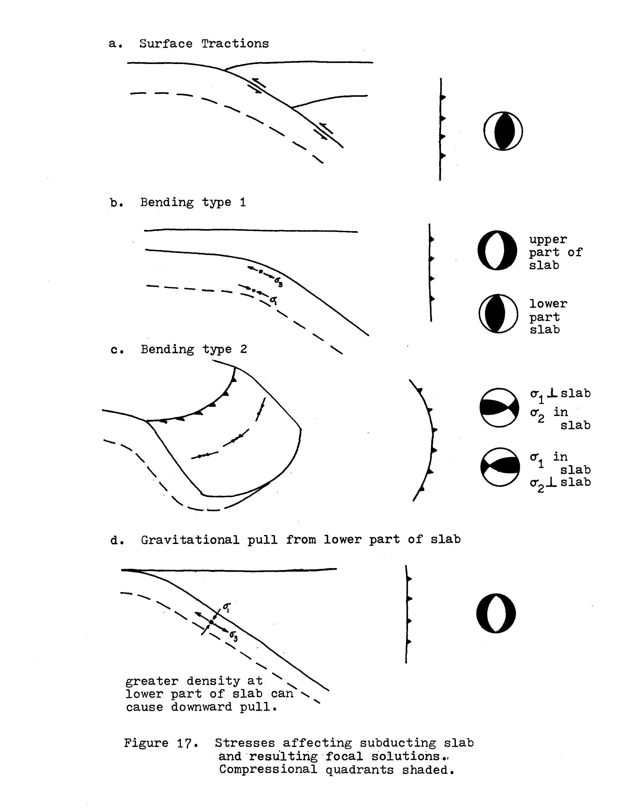
The contradictory interactions of types 1 and 2 bending stresses can result in a less uniform geometry. Type 2 bending tends to oppose type 1 bending. Combinations of the two might facilitate breakup of the slab into discontinuous blocks. If both types of bending are occurring in one location, it is likely that type 1 would dominate the stress field in the upper part of the slab and type 2 would become important deeper, though not necessarily dominant.
Gravitational forces acting on the downgoing slab can add an additional stress in addition to being the ultimate driving force behind the others. A gravitational pull from the lower part of the slab might result in a tensional stress component along the dip of the slab, depending on how efficiently the slab acts as a stress guide.
The fault-plane solutions of figure 16 can be interpreted as combinations of these various stress-inducing mechanisms. For example, the 1965 Tacoma earthquake (D) can be interpreted as due to dominantly tensional stresses in the upper part of a plate bending to a steeper dip angle (Davis, 1977). The 1949 earthquake (E) was apparently located deeper in the slab (70 km) and may be showing the effects of increased type 2 bending stresses. It should be noted that these are only possible explanations and that earthquakes in this depth range are most likely not accurately located. But they serve to exemplify how complex stress fields can be manifested.
LOCAL TECTONICS
The evidence presented above demonstrates a rather high level of tectonic activity for the Puget lowlands area. The Tertiary basin relief, and probable basement relief suggested by the gravity, reflection seismology, and drilling data, show large offsets occurring at least through the Pleistocene. The present seismicity suggests that this activity is continuing at all levels of the crust and apparently into the upper mantle. The “Seattle-Bremerton fault” of Rogers (1970) may be a still-active reverse fault zone which extends entirely through the crust and into the mantle. As such, it is a very interesting feature. The southern limit of this seismicity coincides approximately with the southern limit of the Puget trough waterways and the southern limit of maximum continental glaciation in the area. Further south, only shallow earthquakes occur (less than 20 km) and at a somewhat lower level of activity than to the north.
According to C. F. Kienle (pers. comm., 1978), a new interpretation of magnetic, gravity, and topographic data places the onshore extension of the major northeast-trending, left-lateral fault zone of the Juan de Fuca plate (fig. 10) along the southern boundary of the Puget lowlands. According to Kienle, the subducted part of the Juan de Fuca plate is probably segmented along several newly identified fracture or fault zones which exist within the plate. If so, different segments may have different geometric configurations, and thus different interactions with the North American plate.
The recurrent loading and unloading of the Puget lowlands area by Pleistocene continental glaciation may have had a weakening effect on the crust in that area. A simple preliminary calculation shows loading stresses are on the order of 100 bars. This is a significant stress contribution and it occurred over a geologically short period of time. Because the time period was short, the rocks probably acted in a rather brittle manner and this may have resulted in crustal fracturing which would facilitate present localization of deformation.
REGIONAL PLATE INTERACTIONS
Much of the present seismic activity in the vicinity of the Gorda Ridge is actually intraplate activity within the Gorda plate. This can be seen well in the regional seismicity map (fig. 10). The greatest concentration of epicenters is in the southeast corner of the plate where the San Andreas fault intersects the Mendocino fracture zone. Most of this seismicity reflects internal deformation of the plate. Fault plane solutions by R. W. Couch (Kienle & Couch, 1977) show a predominance of strike-slip faulting in this area. Some researchers are proposing that the San Andreas fault now extends through the Gorda plate to about the middle of the Gorda Ridge. The broad zone of deformation shown by the magnetic anomaly pattern and the pattern of seismicity suggest that this is a transition period and that part of the right lateral motion is taken up at the Mendocino fracture zone and part within the Gorda plate.
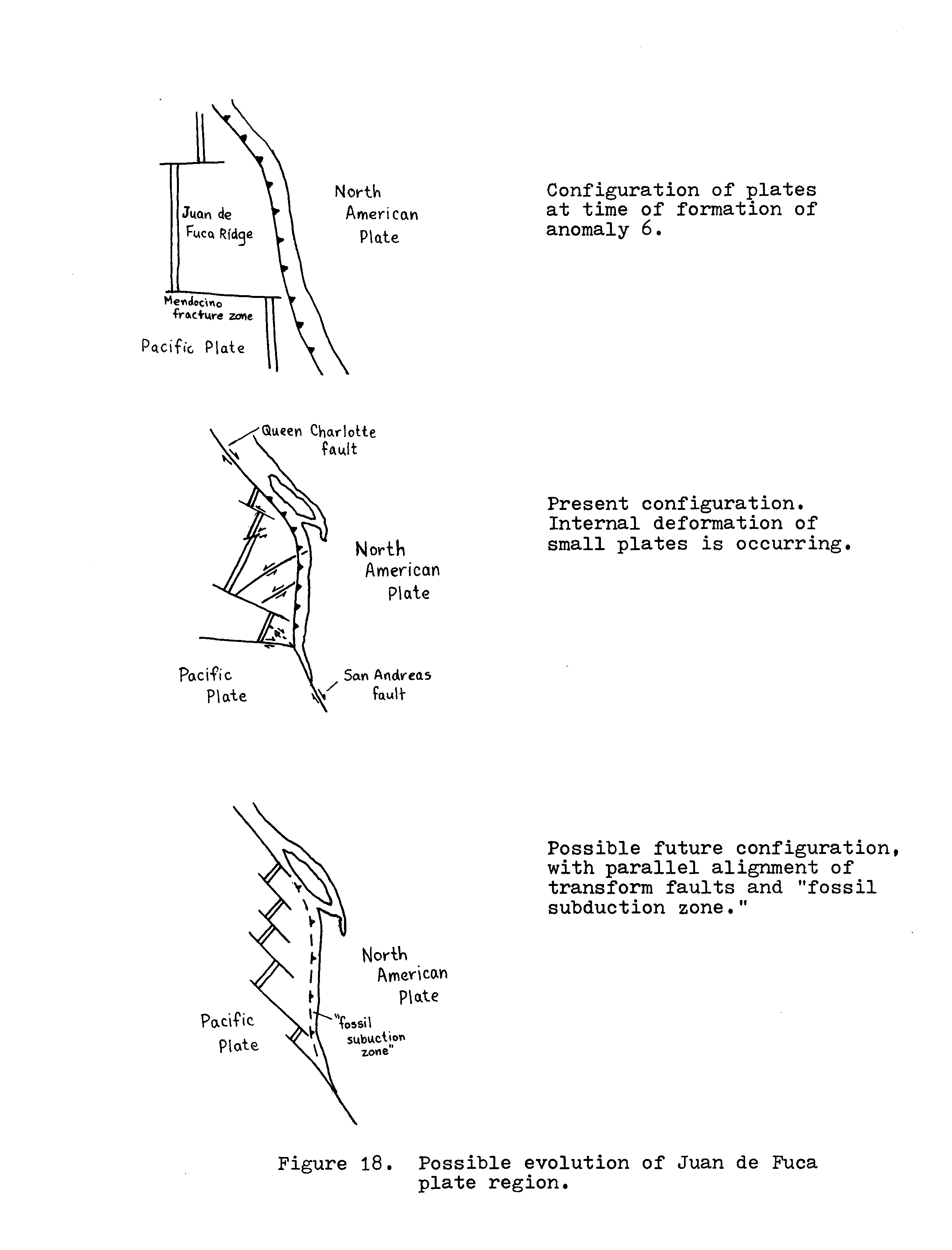
Northeast trending left-lateral fault zones in the Juan de Fuca plate indicate that some deformation has already taken place here. This has probably resulted from rotation of the plate into better alignment with the Pacific-North American relative motion. The plates may realign eventually to eliminate the subduction zone altogether (fig. 18). If so, further deformation of the Juan de Fuca plate is required. The rotation of the spreading centers indicated by magnetic lineations and the accompanying internal deformation indicate that this is not merely a passive realignment of spreading centers as originally discussed by Menard and Atwater (1968). It suggests, rather, that some sort of drag is being experienced between the Juan de Fuca and North American plates. Similar interaction between the Pacific and north American plates is apparently responsible for right lateral faulting over a broad region surrounding the San Andreas fault in California (Atwater, 1970).
In the western Washington region, the plate geometry requires that some convergence be continuing between the Juan de Fuca and North American plates, but that the motion is oblique with a large component (probably the major component) of right-lateral relative motion. This component is probably responsible for the deformation seen in the oceanic plates. It is also probable that this motion is responsible for the generally north-south compressive stress field in the Pacific northwest.
If the subducted part of the Juan de Fuca plate is segmented, and different segments have different depth profiles, it is likely that some segments are more efficient than others at transmitting stresses to the upper plate. In effect, these areas would be carrying the load for other areas which may be thought of as decoupled. This may be what is occurring in the Puget Sound area. The abundance of north-south compressive seismicity and the anticlinal folding of the Olympic Mountains are perhaps indicative of preferential stress transmission to this locale.
CONCLUSIONS
The major conclusions shown by this study are as follows:
- The geophysical information shows the Puget trough to be a tectonically active area. Offsets in basin topography are youthful and in some cases apparently active.
- The high-level regional stress picture is, in general, one of approximately north-south compression with probable local variations. This stress field is probably the result of interaction of the upper plate with obliquely subducting segments of the Juan de Fuca plate.
- The localization of seismicity in the Puget Sound region may be due to a difference in interaction between two segments of the downgoing slab. The boundary is probably an eastern extension of a fault zone within the Juan de Fuca plate.
- Although subduction can not be physically proven to be occurring at the present time, convergence is geometrically required until the oceanic ridge transform faults realign parallel to the direction of relative motion between the Pacific and North American plates.
SUGGESTIONS FOR FUTURE STUDY
Additional data on earthquake hypocentral locations is available from the state of Washington. If used, they would provide more accurate distribution patterns of shallow events, and may show seismicity patterns for subcrustal events. A study of the seismic dispersion patterns for western Washington may yield information on the geometry of subducted lithosphere which may tend to confirm or refute conclusions of this paper.
ACKNOWLEDGMENTS
Many thanks are due those who made this study possible and assisted me in its completion. Greg Davis of the University of Southern California suggested the topic and gave helpful criticisms of the report. Dave Tilsen and Bill Kiel of WPPSS were of great assistance in obtaining data. C. F. (Rick) Kienle of Shannon and Wilson Inc., Portland, provided additional data and a couple of thought provoking discussions on regional tectonics.
REFERENCES CITED
Atwater, Tanya, 1970, Implications of plate tectonics for the Cenozoic tectonic evolution of western North America: Geol. Soc, Am. Bull., v. 81, p. 3513-3535.
Berg, J. W., Jr., et al, 1966, Crustal refraction profile, Oregon Coast Range: Bull. Seismol. Soc. Am., v. 56, p. 1357-1362.
Crossen, R. S., 1972, Small earthquakes, structure, and tectonics of the Puget Sound region: Bull. Seismol. Soc. Am. v. 62, p. 1133-1171.
Crossen, R. S., & Millard, R. C., 1975, Compilation of earthquake hypocenters in western Washington – 1974: Wash. Div. Geol. & Earth Res. Info. Circular 56, 14p.
Danes, Z. F., et al, 1965, Geophysical investigation of the Puget Sound area, Washington: Jour. Geophys. Res., v. 70, p. 5573-5580.
Davis, G. A., 1977, Tectonic evolution of the Pacific Northwest: Precambrian to present: Subappendix 2R-C, Prelim. Safety Analysis Report, Amend. 23, Nuc. Proj. No. 1, 46 p., Washington Public Power Supply System.
Dehlinger, P., Couch, R.W., Gemperle, M., 1968, Continental and oceanic structure from the Oregon Coast westward across the Juan de Fuca Ridge: Canad. Jour. Earth Sci. v. 5, p. 1079-1090.
Dehlinger, P., Couch, R. W., McManus, D.A., Gemperle, M., 1971, Northeast Pacific structures, in The Sea, v. 4, New York, John Wiley & Sons.
Dickinson, W.R., 1970, Relation of andesites, granites, and derivative sandstones to arc-trench tectonics: Rev. Geophys. v. 8, p. 813-860.
Dickinson, W.R., 1975, Potash-depth relations in continental margin and intra-oceanic magmatic arcs: Geology, v. 3, p. 53-56.
Dickinson, W.R., 1977, Written communication to Gregory A. Davis.
Hall, J.B., & Othberg, K.L., 1974, Thickness of unconsolidated sediments, Puget lowland, Wash.: Wash. Div. Geol & Earth Res. Geologic Map GM-12.
Huntting, M.T., Bennett, W.A.G. , Livingston, V.E. Jr., Moen, W.S., 1961, Geologic Map of Washington, Wash. Div. Mines & Geol.
Kienle, C.F. Jr., 1978, Personal communication to K. A. Piper.
Kienle, C.F. Jr., & Couch, R.W., 1977 Preliminary Analysis of late Quaternary indicators of plate tectonics in the Pacific Northwest: unpublished report prepared for Washington Public Power Supply System.
Livingston, V.E., 1958, Oil and gas exploration in Washington, 1900-1957: Wash. Div. Mines & Geol. Info. Circular 29.
MacLeod, N.S., Tiffin, D.L., Snavely, P.D. Jr., & Currie, R.G., 1977, Geologic interpretation of magnetic and gravity anomalies in the Strait of Juan de Fuca, U.S.-Canada: Can. Jour. Earth Sci. v. 14, p. 223-238.
Mathews, W.H., Fyles, J.G., Nasmith, H.W., 1970, Postglacial crustal movements in southwestern British Columbia and adjacent Washington state: Can. Jour. Earth Sci. v. 7, p. 690-.
Menard H.W. & Atwater, Tanya, 1968, Changes in direction of seafloor spreading: Nature, v. 219, p. 463-467.
Riddihough, R.P., & Hyndman, R.D., 1976, Canada’s active western margin — The case for subduction: Geoscience Canada, v. 3, p. 269-278.
Rogers, W.P., 1970. A geological and geophysical study of the central Puget Sound lowland: Unpub. Ph.D. dissert., Univ. of Washington.
Shannon & Wilson, Inc., 1975, Seismicity map prepared for Portland General Electric Co.
Stuart, D.J., 1961, Gravity study of crustal structure in western Washington: U.S. Geol. Surv. Prof. Paper 424-C, Article 248, p. 273-276.
Washington Public Power Supply System, 1974, Geology and Seismology, Section 2.5, Prelim. Safety Analysis Report, Nuclear projects 3,5.
Weston Geophysical Research Inc., 1977 Geophysical and seismological studies in the 1872 earthquake epicentral region: Subappendix 2R-E, Nuclear Proj. No. 1, Washington Public Power Supply System.